Research Movies 2003
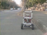
OutdoorAutonomous Navigation using a Laser Range Finder
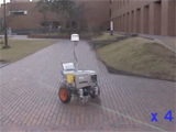
Using odometry, GPS and LRF for navigation for a big-size yamabico robot. Precision of navigation using GPS near tall obstacles is reduced, so a LRF is used to correct the position.
3D Geometric Map of the University Campus
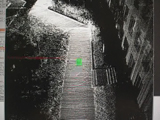
Using Odometry, RTK-GPS and Laser Range Finder, a 3D model map of the University of Tsukuba was built.
Research of a pipe navigating robot using a FG Distance Sensor
Development of a robot navigating through gas pipelines using vision
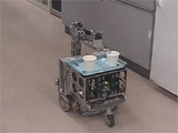
Research of an autonomous tea service robot (Serving Tea Behavior)
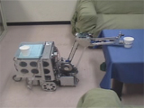
Robot system that serves tea to the Laboratory guests. The robot recieves the tea cup and takes it to the guests table.
Research of an autonomous tea service robot (Tidying up Behavior)
Tidying up demonstration. Robot recognizes and measures the cup position using vision and takes the cup to the sink.
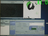
Map Building and Mobile Robot Localization Using a Particle Filter
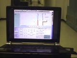
Fusion of odmetry data and Laser Range Finder data using a particle filter for localization.
Automatic Vacuum Cleaner Robot using a roof camera for image processing
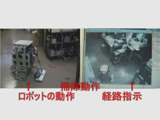
The robot autonomously runs and clean through the path selected by the user. The user selects with the mouse where the robot should clean and using a camera on the roof for image processing the robot cleans the path and correct its position.
Human Assisted Information Acquisition System for Indoor Environment with a Teleoperated Mobile Robot
This system provides the environmental map including the most relevant environmental information by human-robot interaction.
Robot navigation in outdoor environments
The robot uses ultrasonic sensors to measure the sidewalk for running parallel to it. The robot speed is 30cm/sec.